Walking Tracks

Raglan is surrounded by beautiful natural bush, mountainous terrain and spectacular coastline. There are heaps of walking tracks in the area that let you explore the raw beauty of New Zealand. Check out some popular tracks below!

Bryant Memorial Walk

Bush to beach track |  Lookout |  Native Bush | 10 min
Take a wander through shady coastal forest from the Bryant Home Crusade Bible camp to Ngarunui Beach.
Mt. Karioi Summit Tracks

Multiple tracks |  Mountain hiking  |   Awesome views! |  Native Bush |  3 hrs
 
Take a trek to the summit of Raglan’s Sleeping Lady – Mount Karioi.

Te Toto Gorge Track

Ancient Maori settlement | Steep descent  |   Awesome views! |  Native Bush | 30 min
The Te Toto coast has a long and diverse history, from destructive volcanoes to ancient Maori settlement.
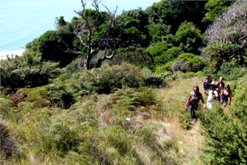
Waireinga / Bridal Veil Falls Walk

Spectacular water fall |  Native Bush | 10 min
Spectacular Waireinga Falls is an short, easy walk from the carpark. The track is Barrier Free to the top of the falls and is suitable for wheelchairs and pushchairs.

Raglan Heritage Trail

The Raglan Museum has installed signs around Raglan with photos and information on heritage sites.

There are also brochures which describe historical buildings and other heritage features including the former Raglan School, the former Putoetoe Redoubt & Courthouse Cottage and the Habourview Hotel. Many are Heritage NZ registered (See entry for the Harbour View Hotel here.).

More detailed Heritage Walk brochures are also available from the iHub and Museum.
https://www.raglanmuseum.co.nz

Raglan Heritage Walks Town brochure
Raglan Heritage Walks Wharves brochure
Raglan Heritage Walks Town map

Rodger Gallagher initiatives via:  https://www.raglan23.co.nz/

Note: You can click on either cover of the Walks brochures to download PDF versions.

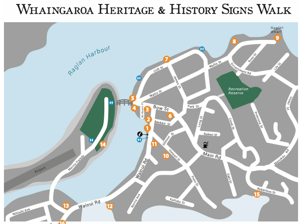
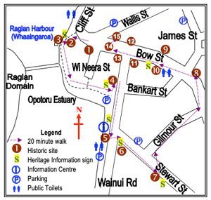
Whaingaroa Heritage & History Signs Walk Map

There is a sign or monument at each of the locations listed, showing photographs and information relating to the history of the site or building.

While some are still in use, for example the Town Hall (6), the Dairy Factory (8) and the Wharf (9), others have changed considerably over the years, for example the Post Office (3) and the Old School (10).

Note: You can click on the Map to download a PDF version.

Town to Beach

Click the map for an enlarged view

1. Town to beach walk – up to 6km

A walk along the sand out to the main beach – Ngaranui. Accessible at all times, except at high tide. Starting in town, head across the footbridge then take a right and follow the beach around the corner along the estuary to the open sea beach.
The full walk is 6km return, so you may turn back earlier.

A short drive away

Click the map for an enlarged view

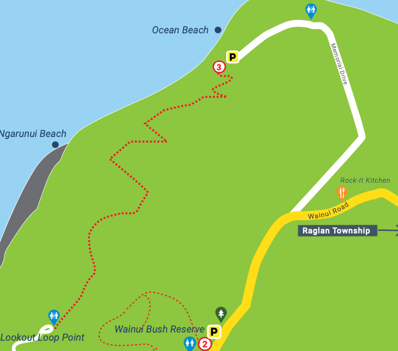
2. Wainui Bush Park – off Wainui Rd.

A network of different paths and loops within the Wainui Reserve area. Tracks include heading to the beach. Enjoy walking through native bush.

3. Te Ara Kakariki.

Te Ara Kakariki, Raglan Ocean Trails, overlooks Ngarunui Beach. The track is also a one-directional bike track, so it is a shared track. The best place to park is at the carpark at the very end of Riria Kereopa Memorial Drive and make your way up to the track from there.

A longer drive away

Click the map for an enlarged view

4. Ngaranui Beach Loop Walk.

Turn right at the roundabout going into Ngaranui beach onto the outlook road. Park at the end of the road in the loop carpark. The track leads off from the carpark, down the hill to the beach. There, make a left until the ramp which leads back up the hill. Continue on to the outlook road. The walk has beautiful vistas of the bay below, native bush, sand dunes and sea.

5A. Water Race Track – 30 min / 1 km

Starts in Upper Wainui Rd, or across the road from the Ngaranui Track on Wainui Rd. This track follows as historic water-race track through regenerating coastal forest.

5B. Water Race track to Solscape Loop

From the southern entrance to the Water Race Track in Upper Wainui Rd, follow the track across the bridge then turn onto the left-hand track. This continues on to the eco village Solscape, where during the summer months there is an excellent restaurant with amazing views of the Raglan bay. Once replenished, follow Wainui Rd to the right, to the northern entrance of the Water Race track and back to your car.

6. Ngarunui Track – 20min / 800m

Start from Wainui Rd, or from Ngarunui Beach. A third of the way along there is a lookout providing excellent views northward along the coast.

A longer walk away

Click the map for an enlarged view

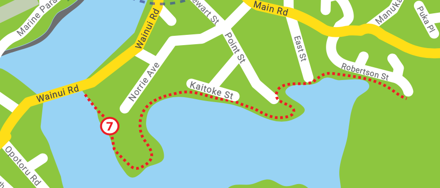
7. Estuary Walk – I hour / 5 km

Access either at end of Robertson St or road before Wainui Bridge to left. This walkway follows alongside the Raglan Estuary, through native bush and a slightly hilly terrain. It can be cut short at any of the side streets that join the track.

Mount Karioi

Click the map for an enlarged view

8. Mt Karioi Track. Time to lookout 2 hr. Time to summit 3 hr.

This is the steeper but more scenic of the two summit tracks. Chains and ladders have been installed to help negotiate the occasional rocky outcrop.
Starting point is at the Te Toto Gorge carpark. Once over the stile at the start of the track, it is all uphill. There are plenty of good vantage points to stop, catch your breath and admire the view. After passing through a grove of kanuka, the track climbs up a grassy slope before reaching the main ridge.

9. Mt Karioi Wairake Track. Time to summit 2 1⁄2 hr.

This is the shorter route to the summit and is not as steep as sections of the Karioi track. Starting from Ruapuke/Karioi Rd, it is a 40-minute walk across private farmland to the bush edge. From there, the track climbs steadily through coastal forest up to the summit. Respect the access privilege which is only available during daylight hours.

10. Papanui Point.

A rocky outpost on the Ruapuke coastline, just north of Ruapuke beach. The point is a wild and rugged cliff that overlooks the Tasman Sea, providing spectacular views of Mount Taranaki on a clear day. Please be careful of tide changes. It can be dangerous if not paying attention to an incoming high tide.

A short drive away

Click the map for an enlarged view

11. Bridal Veil Falls / Wairenga 10–20 min.

This is a 55m high waterfall located 20 min south of Raglan. From route 23, turn off at Te Mata Rd then left into Kawhia Rd. A short 10 min easy walkway will take you to two lookouts at the top of the falls. Another 15 min of stairs will get you to the bottom of lookout platform.

12. Pipiwharauroa Trail / Te Uku Windfarm. 18 km return trip. 4 hrs walk / 2 hr bike ride.

Starting point is just after Bridal Veil Falls on Kawhia Rd. The farm track goes over privately owned farmland on the Whararauroa Plateau crossing steep to rolling terrain. Please make sure that if farm gates are closed, that they remain closed once you have passed through. From August to September, sections of the trail are closed for lambing.

A longer drive away

Click the map for an enlarged view

13. Ed Hilary Reserve Raglan.

The reserve adjoins the Four Brothers Scenic Reserve (and the Karamu Walkway), midway between Hamilton and Raglan on SH23. The entrance is on Old Mountain Road (approximately 826 Old Mountain Road), Waitetuna.
Tracks begin at the main entrance off Old Mountain Road. Tracks are clearly signed and easy to follow from the carpark. There is a small car park and picnic area at the main entrance and a toilet through the entrance gate towards the track start.

14. Four Brothers Track. 15 min / 630m one way.

Start at the Four Brothers Scenic Reserve car park on the Hamilton-Raglan Highway (SH23). A moderate 15-minute climb through bush leads to the reserve’s southern boundary, open farmland and good views.

15. Karamu Walkway – northern track. 1.5 hr one way / 2.7 km.

Start from the car park on the Hamilton-Raglan Highway along the Four Brothers Track before crossing open farmland. This section of the walkway is across private land so respect the owner’s rights. Follow the white posts and orange markers along the main ridge to Old Mountain Rd. There are great views of the Hakarimata Range in the north, Karioi and the coast to the west, Pirongia to the south and Hamilton city to the east.

16. Karamu Walkway – southern track. 3-4 hr one way / 7.8 km.

This section starts on the south side of Old Mountain Rd. After an initial climb you cross pasture studded with outcrops of limestone before dropping down to bush. It can be slippery when wet. Follow the markers above the limeworks mill to the car-park, and then out to Fillery Road.
Note: to access Karamu Walkway from the Karamu end, turn off Limeworks Loop Rd on to Fillery Rd, cross the one-lane bridge then follow the signs along a farm track to the carpark. If you don’t want to retrace your steps back along the track you will need to arrange transport from either Limeworks Loop Rd or Old Mountain Rd.

A longer drive away

Click the map for an enlarged view

17. Karakariki Reserve – near Whatawhata. Waterfall 20 min, fenceline 1 hr.

From Raglan on SH23, turn left into Karakariki Rd To Karakariki Valley Road carpark. A 20 min walk will get you to waterfall – picnic and dip into the water. You can explore further upstream.

18. Waipa River Walkway.

Start in Te Pahu Rd, just off route 23. Look for a track behind the church, on the river side of the fence, and follow the orange markers. Here you will leave the road to walk on the true left bank of the Waipa River for a way.
The track runs through pasture and swamp to a footbridge and in places, goes along a farm race – please, always give way to cattle!
At one point, the track heads back onto Te Pahu Rd and across a road bridge (Paratawa Stream) before orange markers lead back onto the river reserve. Then it’s back onto Te Pahu Rd to the junction with Old Mountain Rd.

Mount Pirongia

Click the map for an enlarged view

19. Nikau Loop Track – Kaniwhaniwha. 2 1⁄2 hr return / 7 km.

The track starts from the Kaniwhaniwha car park where It follows along the stream to a loop walk with nikau palms and tree ferns. There is a picnic/campsite with toilets a short distance off the track.
This walk can be combined with the Kaniwhaniwha Caves adding 30 minutes to the walking time. The two limestone caves are near the start of the Bell Track, 5 minutes from the junction with the Nikau Walk. You can walk through the 20 metre long main cave, but note there is a short hands-and-knees crawl. Torches are required
The track is ideal for family cycling but do follow directional signs around the loop track. This is a shared-use track.
Good for families. Swimming and picnicking along the stream.
From Raglan take SH23 to Waitatuna Valley Rd, then right onto Limeworks Loop Road and on to Kani- whaniwha Reserve

20. Bell Track – from Kaniwhaniwha carpark. 6-10 hours one way /18 km.

Follow the Nikau Walk on to the Bell Track and past the Kaniwhaniwha Caves. Cross the bridge near the
big kahikatea and climb a spur to a series of clearings. The last clearing signposted as the halfway point has
a small stream nearby and is a good campsite. The track becomes quite muddy at this point and continues along the ridge to the Cone (second highest point on the mountain) and then to Pahautea Hut (bookings not required). It is another 30 min to the summit of Pirongia.

21. Tahuanui Track from Kaniwhaniwha. 4-5 hr one way / 10.7 km.

Follow the Nikau Walk to the campsite. The Tahuanui Track leaves the campsite beside the stream and climbs steadily up a ridge to join the Tirohanga Track before the summit and the Pahautea Hut.
A good level of fitness is required.
Water is difficult to find, especially in summer, so be sure to take sufficient drinking water with you.

22. Corocon Road lookout. 15 min return / 100m.

From Raglan route 23, turn south onto route 39. 5.5 km north of Pirongia, turn off SH39 onto Te Pahu Road, which is signposted for Pironga Forest Park. After 5.6 km, turn into Corcoran Road and follow this to the end.
Suitable for wheelchairs, this track leads through forest from Corcoran Road end to a picnic area and view point. There are extensive views across the Waikato Basin to Hamilton and Te Aroha Mountain beyond.

23. Ruapane Lookouts

For excellent views across Waikato Basin, and for family groups with moderate fitness, two tracks lead to Ruapane Trig (723 m) .
Tirohanga Track 1 hr one way. 2 km.
A steady climb from Corcoran Road along the Tirohanga Track leads to Ruapane Trig. The track starts from the car park and follows a formed track up steps. Nearer the top, the formed track ends and a tramping track leads up over rock to the trig view point.

24. Ruapane Track – 1 1⁄2 hour one way / 4km.

5.5 km north of Pirongia, turn off SH39 onto Te Pahu Road, which is signposted for Pironga Forest Park. After 4.7 km, turn into Waite Road and follow this to the end.
Ruapane Track starts at the Waite Road car park and follows up a slippery gully before reaching the bush edge. From here, the track follows a ridge that becomes steeper as it reaches the junction of the Tirohonga Track. It then climbs steadily up a rocky outcrop to the trig.

25. Tihoranga Track – 3-5 hr one way / 6.5 km.

5.5 km north of Pirongia, turn off SH39 onto Te Pahu Road, which is signposted for Pironga Forest Park.
After 5.6 km, turn into Corcoran Road and follow this to the end.
The track starts from Corcoran Road, climbs to Ruapane then traverses an undulating ridge on uneven ground before passing Tirohanga Bluff, a pinnacle of hard lava signifying its volcanic origins. The track then descends and climbs before reaching the Pirongia summit. On a clear day look for Mt Taranaki and Mt Ruapehu in the distance.

26. Mahaukura Nature Walk. Family friendly walk.

The Mangakara Nature Walk loop track at the end of Grey Road in Pirongia Forest Park, takes about one hour to complete. It is accessible to people of most ages and fitness levels.

27. Mahaukura round trip – 4-6 hr one way / 9 km.

From Grey Road car park, follow the track to Wharauroa Lookout then on for another 30 min to Mahaukura. From Mahaukura, the track descends steeply before climbing again towards Pirongia summit viewing tower. This track can also be accessed off O’Shea Road via the Wharauroa Track.
Getting there: The track starts 11 km north of Pirongia. 5.5 km north of Pirongia, turn off SH39 onto Te Pahu Road. Take the first left turn into Hodgson Road, then turn left turn into Grey Road and follow this to the end.